
Archives
-
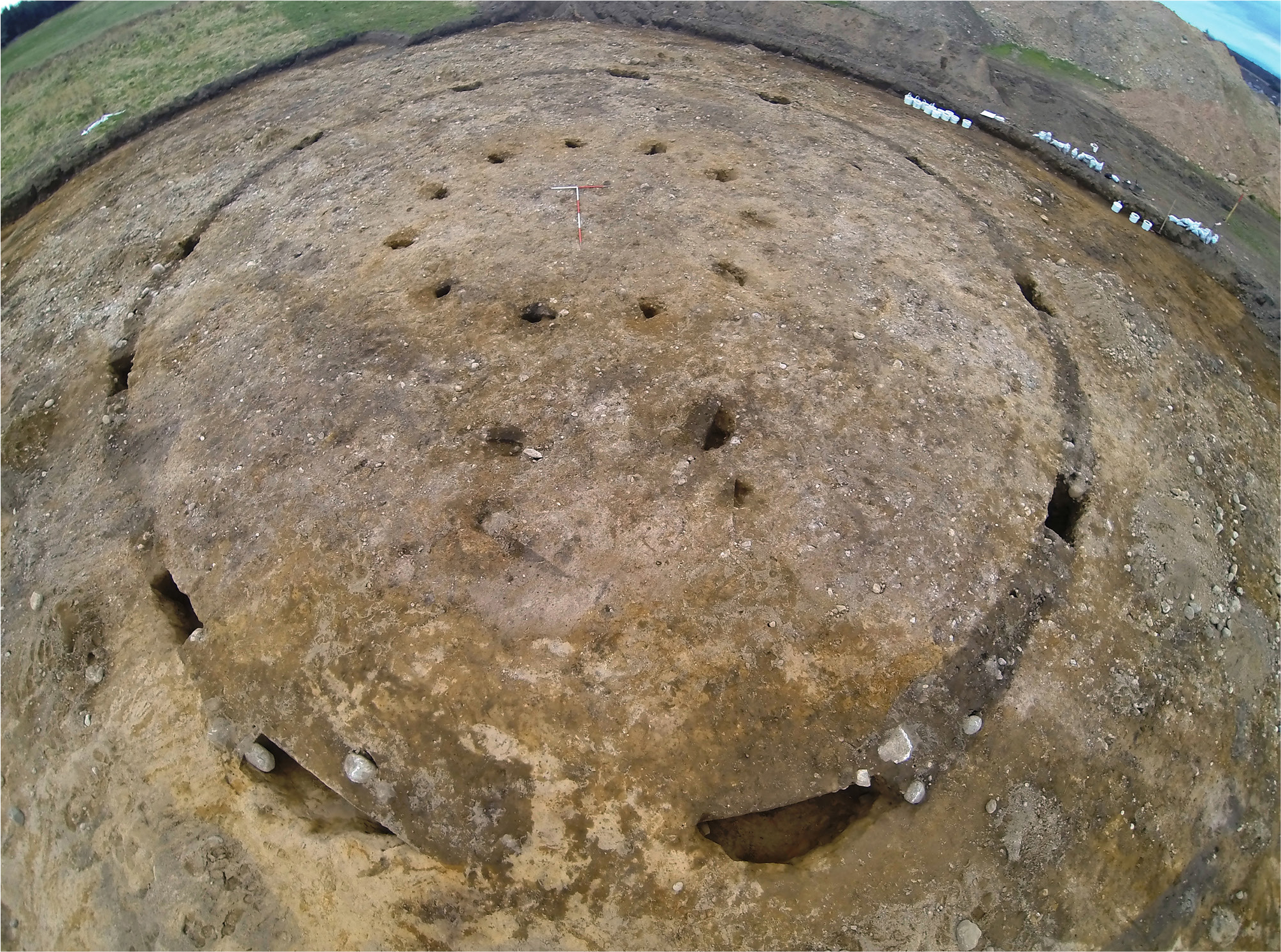
Prehistoric and Medieval Activity at Grantown Road, Forres, Morayshire
Vol. 110 (2025)Prehistoric and Medieval Activity at Grantown Road, Forres, Morayshire
Authors: Lindsay Dunbar
Contributors: Julie Dunne, Richard Evershed, Rob Engl, Toby Gillard, George Haggarty, Simon Howard, Dawn McLaren, Ann MacSween, Andrew Morrison, Jackaline Robertson and Mike Roy
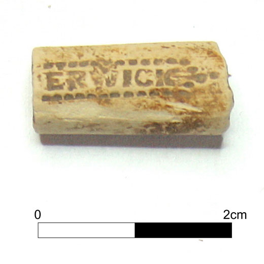
Summary: Archaeological excavations conducted in 2017 at Grantown Road, Forres form the final phase of works on a residential development that began in 2002. The earlier works examined an area of more than 70ha and confirmed the presence of an extensive Iron Age settlement represented by ring-ditch, ring-groove, and post-ring structures, in association with four-post structures, a souterrain, and metalworking furnaces. The 2017 works (Canmore ID 320363), reported here, have expanded the record of prehistoric and medieval settlement in the area and revealed that a previously recorded cropmark site represented an Iron Age enclosure with a single post-ring roundhouse. Also identified in the present works were an Early Neolithic post-ring structure and a series of pits dating from the Neolithic to the medieval periods with artefact assemblages of pottery, lithics, and stone tools, including a rare fragment of a locally made mortar dated to the 13th century ad.
Keywords: Neolithic, Iron Age, medieval, enclosure, post-ring, roundhouses, mortar
Location: Grantown Road, Forres, Morayshire, (NJ 03255730), Scotland, UK
Periods: Mesolithic, Neolithic, Chalcolithic/Bronze Age, Iron Age, Medieval
Canmore ID: 320363

This work is licensed under a Creative Commons Attribution-NonCommercial 4.0 International Licence.
-

Tarbert Castle, Argyll: Community Excavations at a Royal Castle of Robert I
Vol. 109 (2025)Tarbert Castle, Argyll: Community Excavations at a Royal Castle of Robert I
Authors: Roddy Regan
Contributors: Derek Hall, Andrew Morrison, Genoveva Dimova, Helen Newton & Ingrid Mainland and Dawn McLaren
Summary: An early historic C7th-C8th date recovered from a deposit sealed below the castle walls raises the intriguing possibility of the site being the ‘Tairpirt Boittir’ mentioned in the Irish annals. The excavation work demonstrated that both the Inner Bailey and Outer Bailey of Tarbert Castle were likely constructed at the same time and not the result of two separate building campaigns as previously thought. The well-preserved medieval deposits that survive across the site, suggest the castle was occupied from the earlier 14th century and the excavated evidence indicates the construction of the castle is likely the work of Robert I. The excavation work has also revealed several important aspects of the construction and layout of the castle confirming the presence of two portcullis gates giving access into the Outer Bailey while shedding light on the corner tower at the southwest of the same enclosure. The excavation also located the remains of one medieval building along with medieval deposits lying on the ridge south of the main castle, these likely confirming the presence of the medieval burgh previously postulated as being located in this area.
Keywords: Castle, Burgh, Tarbert, Knapdale, Argyll, Medieval, Robert I, Excavation
Location: Tarbert (NR 86770 68730), Scotland, UK
Periods: Medieval
Canmore ID: Tarbert Castle 39316; Tarbert Medieval Burgh 39321
This work is licensed under a Creative Commons Attribution-NonCommercial 4.0 International Licence.
-
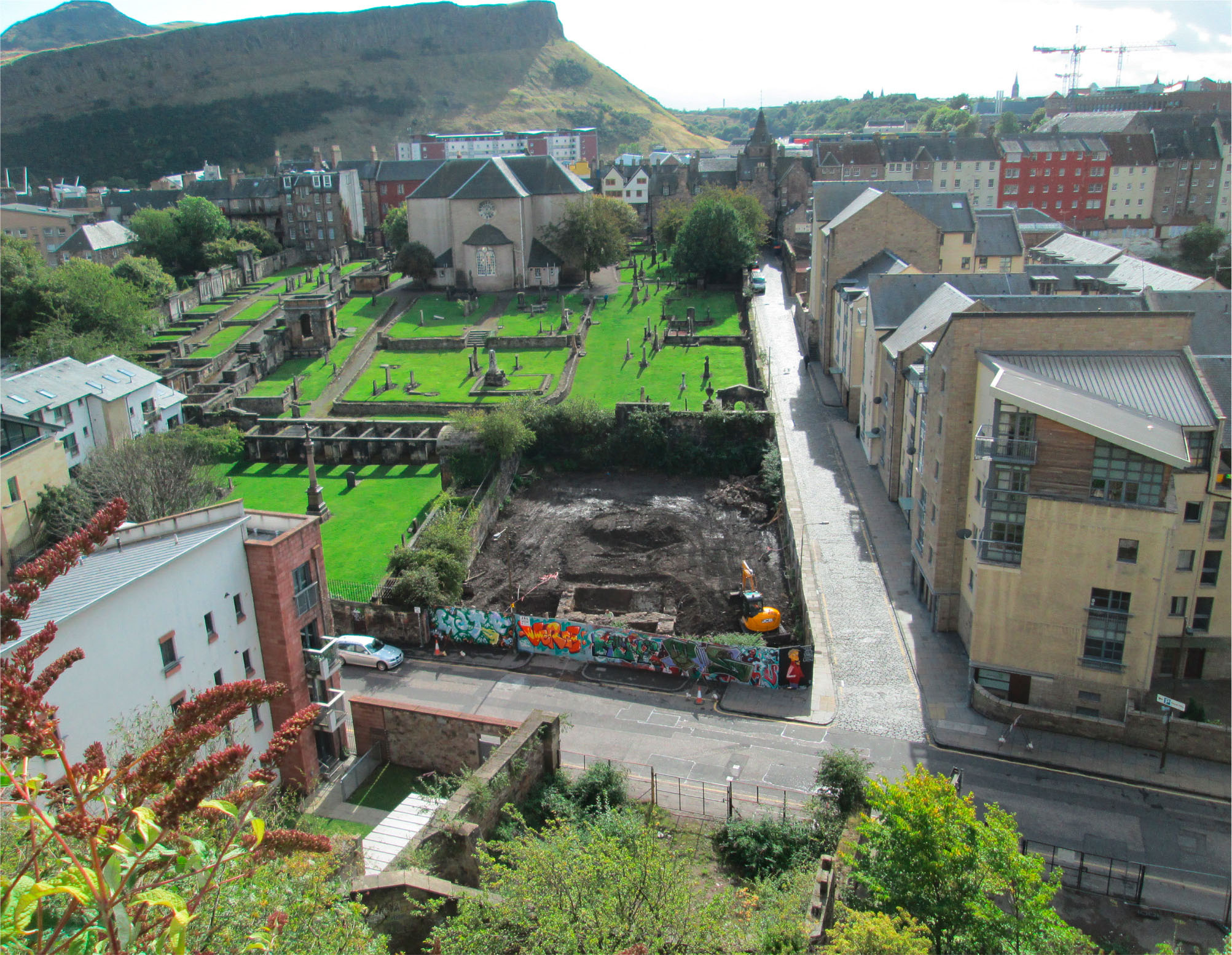
Rich Man, Poor Man: Excavations at the Canongate Poorhouse, New Waverley, Calton Road, Edinburgh
Vol. 108 (2025)Rich Man, Poor Man: Excavations at the Canongate Poorhouse, New Waverley, Calton Road, Edinburgh
Authors: Rob Engl and Martin Cook
Contributors: Thomas Bradley-Lovekin, Anne Crone, Dennis Gallagher, George Haggarty, Derek Hall, Rachel Ives, Alexandra Johnson, Dawn McLaren, Jackaline Robertson, Hugh Willmott and Penelope Walton-Rogers
Summary: In 2013 excavation works were undertaken at the location of the former Canongate Charity Poorhouse (or workhouse) on the New Waverley development site, at the junction of Calton Road and Old Tolbooth Wynd, Canongate, Edinburgh. The excavation revealed development of the site from the initial cultivation of the ‘backlands’ in the 12th/13th centuries to the construction of the Poorhouse in 1761.
A sequence of buried garden soils/middens relating to pre-18th-century activity was recorded, in addition to the remains of a single burgage plot boundary and associated rig and furrow deposits. Substantial structural features related to the 18th-century Poorhouse were revealed, including sandstone walls with wooden plank and pinion foundation rafting. Seven burials of probable late 17th-/early 18th-century date associated with the Canongate Kirk were recorded along the site’s southern boundary (an eighth had been encountered in 1997).
A rich artefact and ecofact assemblage was recovered from the soils and midden deposits, including imported fine glassware. The ceramic assemblage included Scottish White Gritty Ware (SWGW), Scottish Post-medieval Reduced Ware (SPMRW) and Scottish Post-medieval Oxidised Ware (SPMOW), together with high-status imported material such as a Spanish gaming piece and a rare German stove tile.
Consumption patterns revealed by the artefact evidence appear to reflect the high status of the Canongate’s inhabitants prior to the greater development of the site during the 18th century. The creation of the Poorhouse stands in stark contrast to this, revealing the changing fortunes of this part of post-medieval Edinburgh.
Keywords: Canongate, poorhouse, cemetery, Caltongate
Location: Edinburgh , Scotland, UK
Periods: Medieval, Post Medieval, Modern
Canmore ID: 160786
This work is licensed under a Creative Commons Attribution-NonCommercial 4.0 International Licence.
-
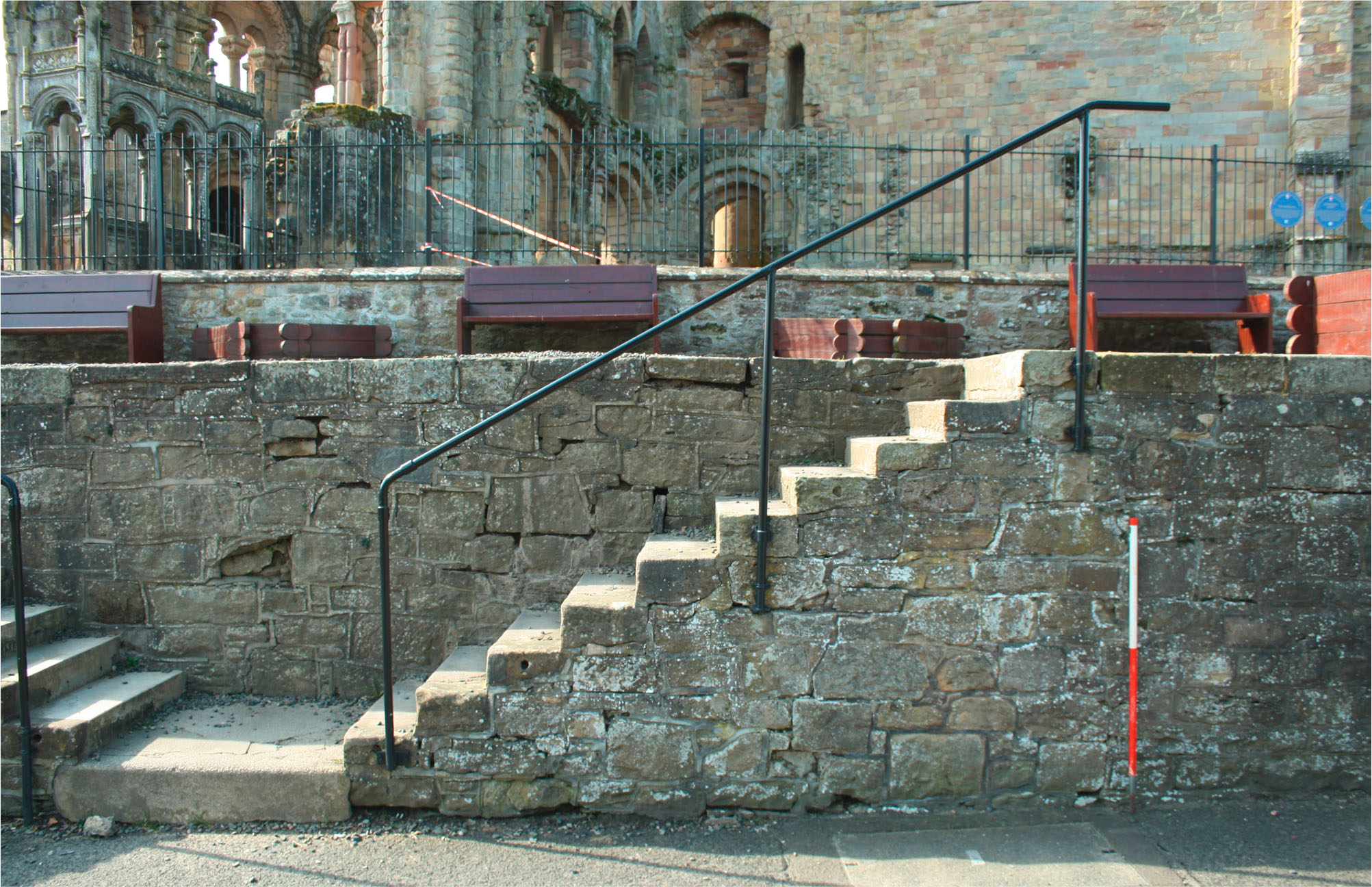
Jedburgh Abbey Rampart: The Treatment of the Dead
Vol. 107 (2024)Jedburgh Abbey Rampart: The Treatment of the Dead
Authors: Ian Hill and Michelle Gamble
Contributors: Derek Hall, Mary Márkus, Alice Blackwell, Jennifer Thoms, Thomas Booth, Kyriaki Anastasiadou, Alexandre Gilardet, Marina Soares Da Silva, Monica Kelly, Mia Williams, Pooja Swali and Pontus Skoglund
Summary: An archaeological watching brief was undertaken at the Jedburgh Abbey Rampart during repair and construction works to consolidate and secure the ‘rampart’ wall and its face, both of which had begun to deteriorate and fail. The watching brief followed on from earlier works to investigate the construction of the ‘rampart’, which had revealed the presence of disarticulated skeletal remains behind the wall. The excavations undertaken during the repair works have helped to infer the methods employed for the construction of the ‘rampart’, likely dating to the late 18th century. During construction several burials of the former Low Kirkyard were disturbed and displaced, with the disarticulated remains of several skeletons found within the construction deposits. The watching brief also revealed the remains of five burials that were partially disturbed during construction, with skeletal remains dating from the 15th century onwards. Disturbance to earlier graves, not disturbed by the construction, were also identified, the results of which indicate changing attitudes to skeletal remains through the post medieval and early modern periods.
Keywords: Late medieval, post medieval, burial practices, Abbey, Scottish Borders
Location: Jedburgh, Scottish Borders, Scotland, UK
Periods: Late Medieval, Post Medieval, Early Modern

This work is licensed under a Creative Commons Attribution-NonCommercial 4.0 International Licence.
-
Cowhides and motorcars: the history of Beaverbank Tannery
Vol. 106 (2024)Cowhides and motorcars: the history of Beaverbank Tannery
Authors: Morag Cross, Magnar Dalland and Debora Moretti
Summary: The proposed development at Beaverbank Place, Canonmills, Edinburgh led to the excavation of the remains of the 19th-century Beaverbank Tannery. Accompanying historical research allowed the history of the ownership and tenancies of the buildings and various businesses to be traced from 1807 to 1959. This included the early 19th-century Clark’s Mill linen bleachers and the 1868 tannery built by the Johnston family and later leased by family firms of the Pringles and Walkers. A period of abandonment between 1913 and 1915 was followed by the repurposing of the building as a sawmill and cooperage. Part of the site changed again to become a motor garage in 1928.
The remains can be matched well with historic map evidence and appear to relate predominantly to the late 19th-century tannery structures. Remains were found of approximately 100 tanning pits set out in a grid pattern, with further features related to drainage, paving and other structures. Very little environmental or artefactual evidence was recovered to shed light on specific practices, materials used or materials produced.
There were also scant structural remains that could be related to the earlier linen bleachers and to the later motor garage.
Keywords: tannery, industrial history, social history, Edinburgh
Location: Beaverbank Place, Edinburgh, Scotland, UK
Periods: Modern
This work is licensed under a Creative Commons Attribution-NonCommercial 4.0 International Licence.
-
Hume Village and Castle: the setting of a late medieval stronghold and post medieval folly in the Scottish Borders
Vol. 105 (2023)Hume Village and Castle: the setting of a late medieval stronghold and post medieval folly in the Scottish Borders
Authors: Ian Hill and Michelle Gamble
Contributors: Derek Hall, George Haggarty, K Robin Murdoch, Fraser Hunter, Calum Robertson, Carl E Savage, Jennifer Thoms, Iain Pringle and Leilani Lucas
Summary: A three-year community archaeology project was completed on behalf of the Hume Castle Preservation Trust at the village of Hume in the Scottish Borders. The project engaged with over 300 members of the public, providing training and volunteering opportunities in a suite of archaeological skills. The project work focused on Hume Village and its surrounding landscape; in particular Hume Castle and the remains of the former medieval village immediately surrounding it, and the associated kirkyard which housed the former Hume Parish Church. Extensive survey work was completed in the kirkyard and adjacent Glebe, in the grounds of Hume Castle, and at the castle itself. Excavations were completed in the castle grounds, the Glebe, and in the garden of West End Cottage in Hume Village. The results of the survey and excavation works portray the changing settlement pattern and use of land in the village area, particularly highlighting occupation and use of the former buildings surrounding the castle up to 200 years after its destruction. A similar pattern was found in the kirkyard, with continual use of the cemetery over 300 years after the abandonment, and probable destruction, of the former kirk. The results indicate that despite the destruction of its castle and kirk, the village of Hume has persevered, maintaining an important sense of place and memory in the landscape.
Keywords: Late medieval, post medieval, community archaeology, folly, settlement patterns, Scottish Borders
Location: Hume, Scottish Borders, Scotland, UK
Periods: Late Medieval, Post Medieval, Early Modern
Canmore ID: 58561, 58559, 58550, 367583
This work is licensed under a Creative Commons Attribution-NonCommercial 4.0 International Licence.
-
‘Sae lofty and wide’: the archaeology of the Clyde Wind Farm
Vol. 104 (2023)‘Sae lofty and wide’: the archaeology of the Clyde Wind Farm
Authors: Stephen Cox and Nuala Marshall
Contributors: Laura Bailey, Julie Franklin, Fraser Hunter and Angela Walker
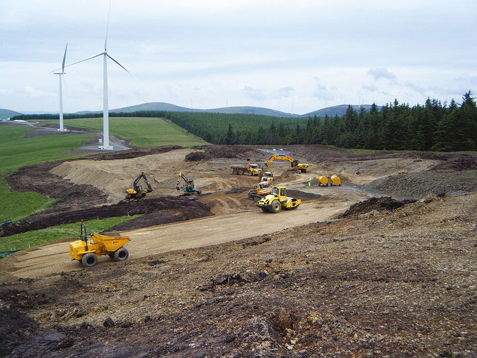
Summary: Archaeological investigations undertaken by Headland Archaeology (UK) Ltd as part of the Clyde Wind Farm and Clyde Wind Farm Extension construction project produced a body of evidence that tells the story of human occupation and settlement in the Upper Clyde Valley. The investigations conducted between 2007 and 2015 included evaluations, site excavations, and the monitoring of groundworks across four distinct landscapes: Clyde Valley North (Woodend), Camps Valley, Midlock Valley, and Clyde Valley South (Newton Plantation). The results of this work, together with those from specialist studies and scientific analyses, have allowed for a range of key research questions to be addressed. These include an exploration of prehistoric upland activities, the role of pits and special places, and the development of settlement patterns and structures. Evidence for mobile Mesolithic and Neolithic communities was identified across the landscape with indications of the repeated visitation of specific locations. The role of pits in the creation of special places was particularly evident across Camps and Midlock Valleys. In the 2nd millennium bc, the hillsides were transformed by the creation of platform settlements. Enclosed settlements and hillforts appeared along the banks of the Clyde Valley in the 1st millennium bc marking a distinct shift in the role of landscape in expressing status and identity. In addition to prehistoric remains, limited evidence of early historic metalworking and medieval rural settlement was uncovered. Across all landscapes and periods, the themes of transition and transformation came to the fore, painting an increasingly dynamic picture of life in the Upper Clyde Valley. The scale and complexity of the archaeological works also allowed for a review of current methodologies, including the role of an Archaeological Clerk of Works, with implications for future strategies.
Keywords: landscape, uplands, settlement, pits, platform, settlement, enclosure, hillforts, routeways
Location: Upper Clyde Valley, South Lanarkshire and the Scottish Borders, Scotland, UK
Periods: Mesolithic, Neolithic, Bronze Age, Roman & Iron Age, early Historic, Medieval
This work is licensed under a Creative Commons Attribution-NonCommercial 4.0 International Licence.
-

A time of change: Mesolithic occupation at Cramond, Edinburgh during the 9th millennium BC
Vol. 103 (2023)A time of change: Mesolithic occupation at Cramond, Edinburgh during the 9th millennium BC
Authors: John A Lawson, Alan Saville and Rob Engl
Contributors: Andrew Bicket, Rosie Bishop, Valerie Dean and Mhairi Hastie
Summary: In 1995 small-scale excavations undertaken at Cramond, Edinburgh revealed a number of pit and post hole features related to temporary or intermittent Mesolithic occupation. These features and associated deposits produced sizeable assemblages of charred plant remains and lithic material.
Cramond appears to be the first of an increasing number of securely dated narrow-blade microlithic sites excavated in recent times along the Forth Littoral. Together with substantial house sites such as Echline Fields, East Barns and Howick, Cramond produced a narrow-blade microlithic industry associated with occupation during the mid-9th millennium BC. As such it remains the earliest narrow-blade type assemblage yet discovered in Britain and provides a jumping off point for the discussion of Mesolithic responses to a rapidly changing environment in terms of population movement and technological change.
Keywords: narrow blade, scraper, flint, microlith, microburin, chert, quartz, hazelnut
Location: Edinburgh, Scotland, UK
Periods: Mesolithic
This work is licensed under a Creative Commons Attribution-NonCommercial 4.0 International Licence.
-

Riddle’s Court, Lawnmarket, Edinburgh: a merchant’s house fit for a king
Vol. 102 (2023)Riddle’s Court, Lawnmarket, Edinburgh: a merchant’s house fit for a king
Author: Michael Cressey
Contributors: Anne Crone, Karen Dundas, Christina Hills and Alasdair Ross
Summary: Riddle’s Court, a former merchant’s house situated off the Royal Mile, Lawnmarket, Edinburgh, underwent major refurbishment and transformation into the Patrick Geddes Centre for Learning from 2015 to 2017. The results from historical research, building survey and architectural watching briefs are as yet unparalleled, as no other building on the Royal Mile has received the level of historical and archaeological research carried out at Riddle’s Court.
In the late 16th century much of the Royal Mile was a plethora of mainly stone and timber-framed houses. However, Riddle’s Court was an amalgam of predominantly ashlar and rubble construction with tall thatched roofs with dormer windows. Slate was a later addition in the early 18th century. The interior of the complex was furnished with several turnpike staircases of which only one now survives. During the 17th and 18th centuries Riddle’s Court was bedecked with all the fine trappings of a country mansion house and was occupied by major and minor aristocracy until the late 18th century. The status of the building was further elevated by its earlier royal connections that led to its partial remodelling for ceremonial purposes. A legacy of a lavish royal banquet in honour of King James VI of Scotland (James I of England) and his bride Queen Anne of Denmark was a painted ceiling in the so-called ‘King’s Chamber’ which commemorated their royal union. This ornate and historically significant painted beam and board ceiling was discovered in the 1960s during a period of building renovation by Edinburgh City Council. The ceiling was restored and is a focal point among a large collection of ornate plaster and painted ceilings. Subsequent removal of more modern lined ceilings during the present refurbishment led to the discovery of three more painted beam and board ceilings, and a concealed fireplace and bread oven that are rare survivors within not only the Royal Mile but elsewhere in Scotland. The presence of so much hitherto unrecorded artwork has significantly raised the importance of the Court’s North Block.
Keywords: Royal Mile, tenement, courtyard, merchant, royalty, painted ceiling, timber, dendrochronology
Location: Edinburgh, Scotland, UK
Periods: post-medieval
Canmore ID: 52291
This work is licensed under a Creative Commons Attribution-NonCommercial 4.0 International Licence.
-

The New Street Gasworks, Caltongate: archaeological investigation of a major power production complex in the heart of Edinburgh and its significance in the industrial development of Britain
Vol. 101 (2022)The New Street Gasworks, Caltongate: archaeological investigation of a major power production complex in the heart of Edinburgh and its significance in the industrial development of Britain
Authors: Dawn McLaren, Mike Roy and Donald Wilson
Contributors: Dennis Gallagher, George R Haggarty, Andrew Morrison, Jackaline Robertson, Lynne Roy, Diana Sproat, Clare Thomas and Ian West
Summary: An extensive programme of archaeological fieldwork between August 2006 and May 2008 in the area of the former New Street Gasworks and New Street Bus Depot, Canongate, Edinburgh revealed remains of one of the earliest and most significant gasworks in Britain. As well as patches of medieval and post-medieval backland soils and post-medieval structures that pre-dated the establishment of the New Street works in the first quarter of the 19th century, substantial structural remains of the various phases of this industrial undertaking were recorded, along with a suite of associated artefacts.
These works have permitted the exploration of the industrial heritage of Edinburgh, as well as revealing important evidence of the medieval and post-medieval occupation of the Canongate. This is the first major excavation of an urban gasworks in Scotland and has enabled an examination of how these gasworks functioned and how they expanded with the introduction of more efficient systems and new technology.
Keywords: gasworks, technology, industrial
Location: Edinburgh, Scotland, UK
Periods: medieval, post-medieval, Modern
This work is licensed under a Creative Commons Attribution-NonCommercial 4.0 International Licence.


